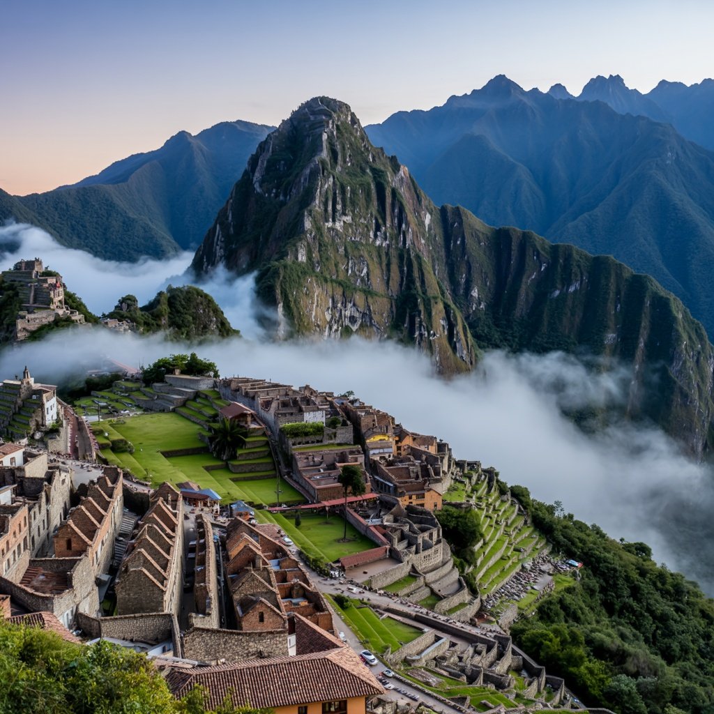
Aguas Calientes, officially renamed Machu Picchu Pueblo in 2020 but still universally known by its original name, serves as the indispensable base for exploring Peru's most iconic archaeological site. Nestled in a dramatic river valley at 2,040 metres elevation, this town of approximately 5,000 permanent residents transforms daily as thousands of archaeological tourists pass through on their pilgrimage to the ancient Inca citadel towering 400 metres above.
As specialists in archaeological expedition planning, we've guided countless visitors through Aguas Calientes, and we've learned that understanding this gateway community significantly enhances the Machu Picchu experience. This comprehensive guide explores the town's unique character, practical considerations, and role in contemporary archaeological tourism whilst examining the broader historical and cultural context of this remarkable location.
The Historical Context of Aguas Calientes
Unlike the ancient ruins it services, Aguas Calientes is remarkably modern. The town emerged only in the 1900s following the completion of the Cusco-Santa Ana railway line, which was built to serve the agricultural operations transporting coffee, tea, and sugar from the montaña (high jungle) region to Cusco and beyond. The railway's strategic route through the Urubamba Canyon created an opportune stopping point where natural hot springs bubble from the mountainside—hence the name "Aguas Calientes" or "Hot Waters."
When Hiram Bingham publicised Machu Picchu to the international community in 1911, Aguas Calientes consisted of little more than railway workers' housing and a few structures serving the train operations. The town's transformation into a tourism hub occurred gradually throughout the 20th century, accelerating dramatically after UNESCO designated Machu Picchu a World Heritage Site in 1983 and particularly following the site's inclusion among the New Seven Wonders of the World in 2007.
The Railway That Built a Town
Understanding Aguas Calientes requires understanding its railway origins. The Ferrocarril del Sur line follows the Urubamba River through increasingly dramatic mountain scenery, covering approximately 30 kilometres from Ollantaytambo to Aguas Calientes. This engineering achievement, completed in the early 20th century, required tunnels through solid rock, bridges spanning turbulent waters, and constant maintenance against landslides and flooding.
The railway remains the primary access method for most visitors to Aguas Calientes, as the town has no road connection to the outside world. This isolation creates a unique character—vehicles are limited to service trucks, buses to Machu Picchu, and the railway itself. The pedestrian-focused environment gives Aguas Calientes an atmosphere distinct from typical tourist towns, though this hasn't prevented intensive commercial development.
Geography and Environmental Context
Aguas Calientes occupies a narrow valley where the Urubamba River—here called the Vilcanota upstream and the Urubamba downstream—has carved through the dramatic mountains of the Cordillera Vilcabamba. The town's geography shapes every aspect of visitor experience, from the steep streets that climb the hillsides to the constant sound of rushing water that provides the acoustic backdrop to daily life.
The Cloud Forest Ecosystem
The town sits within the transition zone between highland Andes and Amazonian lowlands, creating what ecologists call cloud forest or montane rainforest. This ecosystem hosts extraordinary biodiversity, including over 200 orchid species, more than 400 bird species, and the iconic spectacled bear. The persistent cloud cover that shrouds the mountains most afternoons gives Machu Picchu its mystical atmosphere whilst challenging photographers seeking clear shots of the ruins.
The region receives significant rainfall, particularly from November through March during the Andean wet season. This precipitation sustains the lush vegetation that cloaks the mountains and feeds the rivers that carved these dramatic valleys. Archaeological tourists should prepare for variable weather regardless of season—mountain microclimates can produce rain even during the supposedly dry months of June through August.
The Hot Springs
The thermal springs that gave the town its name remain a popular attraction, particularly for visitors returning from Machu Picchu seeking to soothe muscles tired from climbing ancient Inca stairs. The springs, located at the northern edge of town about a 15-minute walk from the plaza, discharge water at approximately 40 degrees Celsius, rich in minerals including calcium, magnesium, and silica.
Whilst the springs provide genuine therapeutic benefits and welcome relaxation, visitors should manage expectations—these are not pristine natural pools but rather developed facilities including changing rooms, small pools, and basic amenities. The water's medicinal properties and the dramatic mountain setting create a worthwhile experience, particularly as an evening activity after returning from the ruins.
The Town Layout and Navigation
Aguas Calientes stretches along narrow valley floor and climbs steeply up surrounding hillsides. The town's geography has forced creative solutions to spatial constraints, with buildings stacked vertically and streets following contours rather than grids. This creates a maze-like quality that can confuse first-time visitors but rewards exploration.
Key Areas and Landmarks
The railway tracks serve as the town's main axis, with most hotels, restaurants, and shops located on either side. Avenida Pachacutec parallels the tracks and functions as the primary commercial street, hosting the greatest concentration of tourist-oriented businesses. The Mercado Artesanal (craft market) dominates the plaza area, offering textiles, ceramics, jewellery, and the inevitable array of mass-produced souvenirs.
The bus station for Machu Picchu-bound vehicles sits across the river, reached by footbridge from the town centre. These switchback-climbing buses provide the conventional route up to the archaeological site, though hardcore enthusiasts can trek the steep trail in approximately 90 minutes. The trail offers rewarding views for those with appropriate fitness levels and adequate time.
Accommodation Options
Aguas Calientes offers accommodation spanning budget hostels to luxury hotels, with corresponding variation in amenities and prices. The town's isolation means prices exceed those in Cusco or Ollantaytambo for comparable quality. However, staying overnight in Aguas Calientes provides significant advantages: early morning access to Machu Picchu before day-trippers arrive, opportunity to visit the ruins across multiple days, and ability to experience the dramatic shift in town character between daytime tourist crowds and quieter evenings.
Location significantly affects accommodation quality and experience. Properties near the railway station offer convenience but suffer noise from trains, whilst hotels clinging to hillsides require stair-climbing but reward with superior views and quieter environments. Our expedition planning services help clients select accommodation matching their priorities, whether emphasising convenience, value, or experience quality.
Dining and Cuisine
Aguas Calientes hosts surprisingly diverse dining options given its size and isolation. Restaurants range from basic set-menu establishments serving traditional Peruvian fare to upscale venues offering creative fusion cuisine. Prices trend higher than mainland Peru due to transportation costs—nearly everything except local water must arrive by train.
Traditional Peruvian Dishes Worth Trying
Visitors should explore traditional Peruvian cuisine whilst in Aguas Calientes. Lomo saltado, a stir-fried beef dish reflecting Chinese-Peruvian fusion, appears on most menus. Alpaca meat features prominently, prepared as steaks, stews, or anticuchos (grilled skewers). Cuy (guinea pig), a traditional Andean protein source dating to pre-Columbian times, challenges adventurous eaters willing to experience authentic indigenous cuisine.
Trout caught from nearby rivers offers fresh, locally-sourced protein. Pachamanca, though typically associated with Cusco and the highlands rather than cloud forest zones, occasionally appears on menus—this traditional earth-oven cooking method produces tender meat and vegetables infused with herbal aromatics. Chicha morada, a sweet drink made from purple maize, provides authentic non-alcoholic refreshment with deep cultural roots.
Market and Self-Catering Options
A small local market serves residents rather than tourists, offering fruits, vegetables, and basic supplies at lower prices than restaurants charge. Budget-conscious travellers can assemble simple meals, though most accommodations lack cooking facilities. The market provides cultural insight into daily life beyond the tourist economy, showing how locals sustain themselves in this isolated community.
The Economics of Archaeological Tourism
Aguas Calientes exists almost entirely as a function of Machu Picchu tourism. This economic monoculture creates prosperity far exceeding typical Peruvian rural communities but also generates vulnerability to disruptions in visitor flows. The COVID-19 pandemic's impact on international travel devastated the local economy, with many businesses closing and residents temporarily migrating to seek work elsewhere.
Tourism's Benefits and Challenges
The concentrated tourism economy has generated substantial income for many residents, funding modern infrastructure, educational opportunities, and healthcare access that would otherwise be unavailable in such a remote location. However, the cost-of-living inflation that accompanies mass tourism has created affordability challenges for service workers who keep the town functioning but don't directly benefit from tourist spending.
The seasonal nature of tourism—with high season from May through September and reduced visitors during rainy months—creates income volatility that affects long-term economic planning. Additionally, many businesses are owned by investors from Cusco or Lima rather than local residents, meaning tourism profits often flow out of the community rather than circulating locally.
Visiting Machu Picchu from Aguas Calientes
Transportation to the Ruins
Most visitors reach Machu Picchu via bus from Aguas Calientes. These vehicles depart continuously from 5:30 AM onwards, navigating the switchback road called the Hiram Bingham Highway in approximately 20 minutes. Return buses operate until 5:30 PM. The bus fare (currently around USD 12 per person each way) is not included in Machu Picchu admission tickets and must be purchased separately.
Hiking the trail as an alternative requires good fitness and allows approximately 90 minutes for the ascent. The trail follows a series of steep switchbacks through cloud forest, offering excellent birdwatching opportunities and avoiding bus queues. However, visitors should assess whether using energy on the climb leaves adequate stamina for exploring the extensive archaeological site.
Timing Your Visit
Machu Picchu admission operates on a timed-entry system with morning and afternoon slots. Early morning visits (first entry at 6:00 AM) offer the best chance of experiencing the ruins with fewer crowds and potentially witnessing the spectacular sunrise dispersing mists from the valleys below. However, these slots require departing Aguas Calientes hotels very early, often before breakfast service begins.
Afternoon entries provide more leisurely morning routines and allow time to explore Aguas Calientes itself. Afternoon light can be superior for photography, particularly as clouds often clear partially in the later day. However, afternoon periods tend to see higher visitor numbers and increased likelihood of rain showers.
Beyond Machu Picchu: Other Activities
Whilst Machu Picchu dominates most visitors' agendas, Aguas Calientes and surrounding areas offer additional activities for those with extra time:
The Mandor Waterfalls
A moderate three-hour round-trip hike following the railway tracks northeast from town reaches the Mandor waterfalls and associated gardens. This trail passes through cloud forest hosting diverse orchid species and birdlife, offering nature enthusiasts an alternative to architectural archaeology. The trail requires care, as it follows active railway tracks for portions of the route.
Putucusi Mountain
For adventurous trekkers with appropriate fitness, Putucusi mountain across the valley from Machu Picchu provides spectacular views of the ruins from a completely different perspective. This challenging climb requires approximately two hours ascending via a series of ladder sections and steep trails, rewarding successful climbers with photographic angles impossible from Machu Picchu itself. The trail can close during wet season due to safety concerns.
The Museo de Sitio Manuel Chávez Ballón
This small archaeological museum, located along the road between Aguas Calientes and Machu Picchu (accessible via bus or on foot), displays artefacts recovered from the ruins and provides historical context often missing from the site itself. Whilst modest, the museum offers valuable background for understanding Inca culture and Machu Picchu's construction. Admission is free, making it excellent value for curious visitors.
Sustainable Tourism Considerations
Aguas Calientes faces significant environmental and social challenges related to concentrated tourism. Visitors can make choices that support sustainability:
- Patronise locally-owned businesses rather than international chains where possible
- Minimise plastic water bottle consumption by carrying refillable bottles
- Dispose of waste properly—litter threatens local ecosystems and water quality
- Respect local residents and their community beyond its tourism functions
- Support conservation-focused tour operators who emphasise archaeological heritage protection
Our archaeological tourism services partner with locally-owned operators committed to sustainable practices that benefit community members whilst protecting the extraordinary natural and cultural heritage that makes this region exceptional.
Practical Information for Visitors
Altitude Considerations
Aguas Calientes sits at 2,040 metres elevation, significantly lower than Cusco (3,400 metres). Most visitors arriving from Cusco find the altitude more comfortable, with reduced likelihood of experiencing altitude sickness symptoms. However, Machu Picchu itself sits higher at 2,430 metres, and treks into surrounding mountains reach considerably greater elevations requiring appropriate acclimatisation.
Currency and Banking
Aguas Calientes has ATMs, though they frequently run out of cash during high season and charge substantial fees. Bringing adequate cash from Cusco proves more reliable. Both Peruvian soles and US dollars are widely accepted, though exchange rates in Aguas Calientes tend to be less favourable than in larger cities. Credit cards work at mid-range and upscale establishments but remain uncommon at budget venues and market stalls.
Connectivity and Communication
Mobile phone coverage in Aguas Calientes is generally reliable with Peruvian carriers, though data speeds can be slow during peak usage periods. Most hotels, restaurants, and cafes offer WiFi, though connection quality varies. Machu Picchu itself has no mobile signal or WiFi, enforcing disconnection that many visitors ultimately appreciate.
Planning Your Aguas Calientes Visit
Determining how long to spend in Aguas Calientes depends on your archaeological interests and available time. The minimum visit spans one night, arriving afternoon before an early morning Machu Picchu visit, then departing afternoon after returning from the ruins. This compressed schedule leaves no buffer for weather problems, missed trains, or leisurely exploration.
We recommend two nights when feasible, allowing either multiple Machu Picchu visits or a more relaxed single-day experience with time to explore Aguas Calientes itself and perhaps hike to the waterfalls or visit the archaeological museum. Three nights accommodates visitors wanting to thoroughly explore Machu Picchu, include the Huayna Picchu or Machu Picchu Mountain climbs (which require separate permits and additional time), and experience the surrounding area.
Our expedition planning services create customised itineraries matching your time constraints, physical abilities, and interests, ensuring optimal experiences whether you're conducting preliminary reconnaissance or undertaking in-depth archaeological study.